As our fast boat, The Edge II, neared the island, Saba's majesty took my breath away. Several jagged peaks clothed in green rise 2855 feet above the surrounding sparkling water.
This was to be a one day trip, it's purpose to hike up to the summit of the highest peak, Mt Scenery. An adventure awaited us.
When we disembarked, a taxi took 10 of us part way up to the hike starting point. As he drove on the one and only island road through 3 of the 4 quaint villages--The Bottoms, St. John's, and Windwardside, he gave us a tour and told us some of the history.
(The Bottom)
We were enchanted by the loveliness of the flora and the cute white cottages with red roofs.Since 1816, Saba has been part of the Kingdom of the Netherlands. The first (and only) road was built in 1943. And what a feat that was! The first airplane landed in 1959. The landing strip is legendary! (only 1312 feet long and the only flat place on the island)
Saba is known for its quaintness, its lush landscape, and amazing undersea life.
*******************
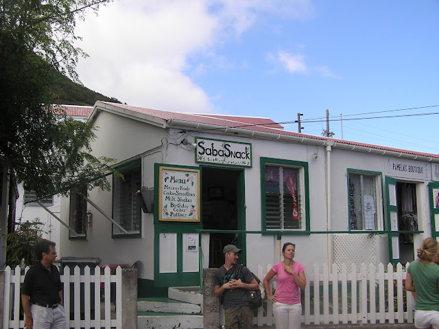
Let's begin this adventure when our driver lets us off at the start of the hike. By the way, don't pay him now, he says. Wait till he picks you up in the Village afterwards. Meet at the Snack Shop.
Let me tell you from the start. We had no idea what we were in for!
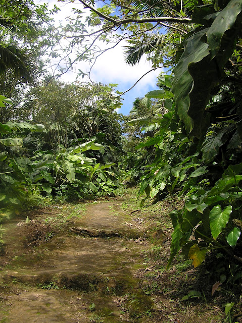
We start our hike UP. It will always be UP. no switchbacks. just UP.
Oh look! We are enthralled by this banana tree. I've seen them before, but never with that humongous inflorescence* hanging off the bottom.
The leaves on many of the plants are jungle-size. Yellow and black butterflies flit lazily.
Up a little ways and we can look down on one of the villages and the sea beyond. How pretty!
UP we go. UP and UP. The way up is by "steps," yet not smooth but rocky and uneven. In places, especially the higher we go, they are slippery. straight UP, no switchbacks.
It's hot and hard work. But there's a view to be had. UP we go.
When we reach the top it feels like a major accomplishment. We look down on a red roof village below.
We see 3 more islands in the distance--St. Kitts, Eustatius, and Nevis.
We can only spare about 10 minutes up here because we have to hike down (those 1064 slippery, scary rock steps) to make our taxi and then our boat back. We brought lunch, but no time to stop and eat. Besides, I'm too hot and tired to eat.
Back down we go. This is easier on the lungs, but still tricky and slippery.
Almost to the bottom now.
We made it!
We have the certificate to prove it! (1064 steps up, 1064 steps down; 1155 foot climb up, 1155 feet down)
We made it!
We have the certificate to prove it! (1064 steps up, 1064 steps down; 1155 foot climb up, 1155 feet down)
shops in Windwardside (snack shop is on the right)
St. Paul's Conversion Church (est. 1860, Catholic)
(middle--a couple who were on our hike; left--my hubby)
We arrive in time to enjoy a smoothie in the outdoor seating area while waiting for our taxi. such jubilation! We did it!!back down to our waiting boat. You can get an idea of the steepness of the mountainside in this photo. Imagine building that road!
NOTE: I took few pictures. The island itself from afar had to be photographed from the inside of the boat through a window. Same thing on the taxi ride. The driver paused a couple times, but otherwise photos were taken while the vehicle was moving--memories for me, not so good to share. On the hike, we were on a mission to get to the top and back down again in time, so I took few photos. I would love to visit Saba again and spend more time. It is an absolutely gorgeous place and the people are wonderful!
FACTS:
■ 5 square miles ■ population 1824 in 2001
■ 4 villages: The Bottom, St. John's, Windwardside, Hell's Gate
■ Dutch is the official language; English is the principal language
■ US dollar is the official currency (since 1/1/2011)
■ Saba University School of Medicine is located in The Bottom (300 students)
■ 2 schools total on the island--Sacred Heart School (primary) and Saba Comprehensive School (secondary)
■ Rainfall averages 42 inches a year. The mean monthly temperature is 80°F. The temperature differs approximately 2 degrees between summer and winter.
■ diverse native vegetation is divided into five types. These occur at different levels above the sea in concentric circles. --grassy scrub near sea level, dry woodland above grassy scrub on the leeward side, moist forest above these, rain forest next, then cloud forest at the summit of Mt. Scenery
LINKS:
■ The airport is among the 10 most dangerous landing strips in the world. See a list of dangerous airports with photos HERE.
■ I liked the story and photos of a hike up Mt. Scenery HERE
■ scuba an snorkel Saba information HERE
*inflorescence--a group or cluster of flowers arranged on a stem that is composed of a main branch or a complicated arrangement of branches.
photos by me © 2012 all rights reserved
I'm linking up with my favorite teacher, Ms Jenny Matlock! See others' completed homework assignments HERE. Come join in! This week our letter is "S."
photos by me © 2012 all rights reserved


Such gorgeous photos! I liked the story you told of your exciting trip! Have a good weekend. Thanks for the lovely share.
ReplyDeleteThanks for that great tour. I've wanted to go there, but never quite made it. I have been to St. Eustatius, aka Statia, tho...and loved it!
ReplyDeleteWhat a beautiful place to have the privilege of visiting!
ReplyDeleteReally lovely -- didn't know about this one and I love finding out about new places.
ReplyDeleteVery interesting, I love these beautiful photos of this wonderful tropical paradise, a very nice place.
ReplyDeleteI can see why they call it Mt. Scenery...the views are gorgeous!
ReplyDeleteWhat an amazing area to visit! The scenery is spectacular. This is what I love about blogging...seeing places I will probably never get to visit! WOW! ♥
ReplyDeleteWow- that's wonderful! I'd love to do something like this:)
ReplyDeleteThat place is beautiful! Interesting facts too. I can see the Dutch influence in the red roof tiles :)
ReplyDeleteWhat an accomplishment to hike all the way up there!
Stunning pictures as always! Thanks for taking us on your journey.
ReplyDeleteWhat a wonderful hike! I was glad to be able to see your photos :)
ReplyDeleteGorgeous photos as always!
ReplyDeleteI am your newest follower, I don't know why I wasn't already :)
Wow, this was stunning and breathtaking, but I don't need to tell you that! I love visiting the Caribbean, where were you staying? Have a great weekend, Nan
ReplyDeleteSo beautiful! I would love to be able to do something like this someday:-)
ReplyDeleteOH, I'm in Love:) Thanks for such an awesome tour. I could definately hide away there...
ReplyDeleteBeautiful! What a wonderful memory for you to have!
ReplyDeleteHow lovely it all is. Funnily enough we have a Sabah here in Malaysia that looks very similar!
ReplyDeleteWhat an interesting sightseeing tour I could make with you ! Such a beautiful place !
ReplyDeleteBeautiful. The perseverance of the people to move there with such a tiny landing strip! But I can see why.
ReplyDeleteErika
It’s a Wrap Link Party at Artful Rising
Hello.
ReplyDeleteThese photos bring back memories of my vacation last year visiting my in-laws for their 50th wedding anniversary. They live on the island of St. Vincent. Great job on your hike & what a lovely certificate gift. Lovely photos of a very scenic place. Thanks for sharing & visiting.
Sitting At My Desk
What a splendid place!
ReplyDeleteVisiting you today was like a tiny little special vacation.
That's a lot of steps! I admire your stamina!
Thanks for linking! I'd definitely love to visit Saba someday!
A+